Digital Twin, Connection to the Mirror World
Apollo 13 was involved in an unexpected accident – the probe’s oxygen tank had exploded. This happened on April 11, 1970, 330 thousand kilometers from Earth. At the time, NASA was unsure of the solution. They could not go out into space and have a look at the probe to diagnose the problem. Instead, NASA had 15 different simulators. By replicating the conditions of the broken probe and repeating tests, they were finally able to find a solution. On April 17, the three lunar astronauts returned safely to Earth.
NASA’s attempt to create an environment identical to the reality and repeat simulations to solve a problem nearly 50 years ago is very similar to the modern ‘digital twin’ technology. Digital twin refers to the replication of the physical world in the digital world. This is why it is also referred to as the mirror world. You can replicate a space or object in 3D to conduct various simulation analyses. In addition, you can create services where the physical and digital worlds are synchronized in real-time. It can also be used in smart city monitoring and predictions, simulating environmental change within a city, innovative mobility services like autonomous driving, robot services and automation systems of a smart building, and in providing people with vivid and realistic 3D content.
The term digital twin is said to be first used in 2002 by Professor Michael Grieves at the University of Michigan. It became more well-known in 2017 when the consulting firm Gartner included digital twin as one of the top 10 most promising technologies. NAVER has already started investment in digital twin from 2016. At this time, the mapping robot M1 demonstrated the creation of a three-dimensional digital twin data of COEX. Afterwards, we unveiled various digital twin technologies that can map entire cities in the 2019 CES event. Ever since, NAVER has been recognized for its technological originality and excellence through numerous large-scale projects.
Features & Advantages of NAVER’s Digital Twin Technology
Digital twin technology has a wide range of subjects, methodologies, and applications. Among them, NAVER focuses primarily on three things.
First, NAVER focuses on massive, megacity-scale digital twins. Compared to digital twins of objects which are primarily used in the manufacturing industry, digital twins of spaces for smart buildings and smart cities face a fundamental obstacle. It is that cities are too large and complex, rendering them unfit for digitalization. A different, innovative approach was needed. In response, NAVER has developed an original solution called ALIKE which utilizes aerial images, mapping robots, and AI. Through this solution, we have created 3D models of the entire Seoul area or digital twins of large-scale, complex spaces such as COEX and Incheon International Airport.
Second, the data can be utilized in a wide array of applications. The most distinct feature of the ALIKE solution is that it enables the construction of digital twins that integrate key data such as 3D models of cities, road layouts, and HD maps. Thus, it is possible to greatly minimize production time and processes while ensuring high accuracy and an extensive range of applications.
Third, NAVER is increasing scalability through the NAVER Cloud Platform. Digital twin solutions require advanced technological capacity and significant costs. Therefore, we have been receiving various requests from many companies and organizations, both domestic and international. In accordance with this trend, we are engaging in the productization of a fully managed cloud-based service which includes the creation and processing of digital twin data and API generation. Through using the product provided by the NAVER Cloud Platform, users can reduce pressure for large-scale investment in the early stages of the business. Also, they can pay according to their resource usage while at the same time, have access to the latest equipment, algorithms, and web-based consoles.
Major Technologies and Activities
1) ALIKE Solution
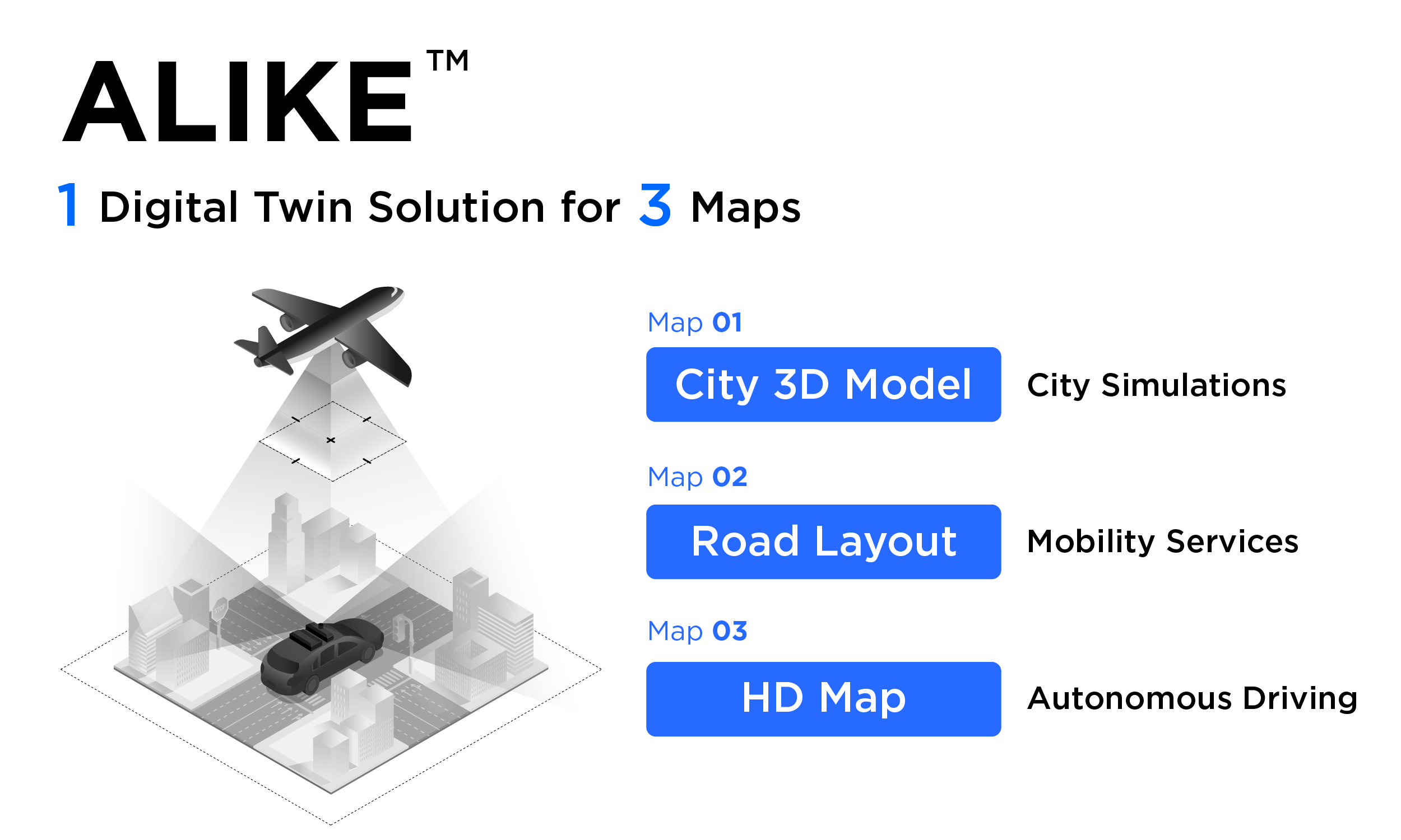
ALIKE-3D : ALIKE-3D is used to create 3D models of entire cities. The key is using aerial photos. Thousands of photographs obtained by scanning an entire city are magically restored into a 3D city through photogrammetry. This 3D model can be used as a simulator to address various urban issues and serves as key data for smart city development.
ALIKE-RD : ALIKE-RD is used to generate precise road information of the entire city. With AI technologies such as deep learning and computer vision, we can automatically extract road marker information and lane information. As the road layouts are highly precise enough to provide lane-level guidance, this solution can be used for diverse mobility services or research into city-wide transportation systems.
ALKE-HD : ALIKE HD is used to create HD maps for autonomous vehicles. By combining the ALIKE-3D model, with high location accuracy, with MMS (Mobile Mapping System) data, we significantly reduced the post-processing procedures for data. This method maximizes HD map production efficiency for intricately intertwined urban roads rather than simple, long stretches of highways.
ALIKE-M : ALIKE-M is used to create digital twins of large-scale indoor and outdoor spaces. Original mapping robots and wearable mapping devices allow users to naturally connect complex environments such as indoors and outdoors, vertical and horizontal spaces, as well as flat spaces and stairways.
Read more on the ALIKE Solution
2) Digital Twin Device
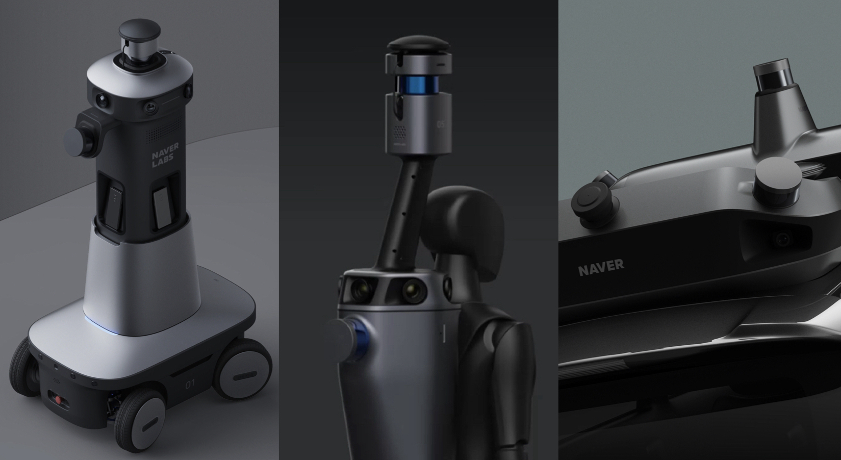
M Series : The M Series are mapping robots developed to efficiently create digital twin data of large-scale indoor spaces. “M” here stands for “Mapper.” This series includes M1, M1X, M2 and etc. Related story
T Series : The T Series are mapping devices intended to create digital twin data of complex spaces such as stairs. “T” here stands for “transformable.” Devices in the T Series can be transformed into various forms such as a wearable type device (T2-B), wheel-based device (T2-M) and so on. Related story
R Series : The R Series is an original mobile mapping system (MMS) developed by NAVER LABS. “R” here stands for “Road.” This series includes the R1 and R3 models. The data collected by the MMS vehicle is utilized by ALIKE-HD to create HD maps. Related story
3) AI
Visual Localization : Visual localization refers to AI technology that analyzes images in order to understand one’s current location. It allows users to precisely determine one's current location even indoors where GPS is not available. NAVER LABS’ has the most advanced visual localization technology in the world. It is currently used in NAVER's indoor autonomous robots and in its AR-based indoor navigation.
Automated road structure perception : AI technology has been applied to the ALIKE solution to automatically recognize and classify lanes and road symbols in aerial images.
Change detection : AI technology that detects changes indoors, outdoors, and on the road has been a topic of dedicated research for many years.
4) 1784, The Testbed
'1784' refers to NAVER's second headquarters, which was unveiled in 2022. The 1784 building itself is an embodiment of digital twin technology. With 8 basement levels and 28 stories, a gross floor area of 1,652,892㎡, and a lot area of 10,909㎡, the entire 1784 building, which can accommodate a total of 5200 workers, is digitalized in 3D. With this, we are continuing various experiments and developments such as service robots, infrastructure control, simulations, and cloud-based control. The massive testbed is being leveraged to accelerate the advancement of our digital twin solutions.
5) Digital Twin As A Service
• ARC eye : ARC eye is a fully managed digital twin service provided through the NAVER Cloud Platform. This enables the creation of digital twin data for vast indoor spaces such as large-scale shopping malls, buildings, and airports, as well as the surrounding outdoor areas connected by pathways. It provides spatial data processing to create three-dimensional HD maps, storage based on need, features to create 2D maps, and AI-based localization APIs.
6) Open Datasets
Since May 2021, NAVER LABS has promoted joint growth by sharing indoor and outdoor digital twin data and localization datasets with researchers, free of charge. We have been providing support so that anyone including academic or research institutes or start-ups interested in this field may apply for datasets and use them for research and technology development purposes. As of June 1st, 2022, the cumulative number of HD map dataset requests reached 1,123 applications. In addition, the number of indoor localization dataset downloads has reached 5,396.